- Continue Shopping
- Your Cart is Empty
June 16, 2015

Insight Into The Life Of A Travel Blogger Duo; The Explorer's Home

Being a travel blogger seems like the perfect part-time activity. Office jobs just don't offer the same thrill and adventure as an outdoors getaway, getting back to nature, exploring new countries and discovering beautiful scenic landscapes.
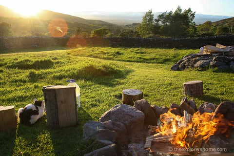
We are delighted to have Vaughan & Katie from The Explorers Home guest blog for us. Expect monthly posts covering travel inspiration, packing tips and more, but to begin with let's get an insight into their lives and daily routine.
Tell us a bit about yourself
Adventure is a part of us all. We can all remember those times of wonder and discovery as a kid when everything we saw was a new discovery and life was full of wonder. Most of us grew up though, filling our days with school, college, work, family… and we lost the adventure somewhere in amongst all of the stuff that fills our time. We want to bring that back for people.
Vaughan Williams (myself) and Katie Cockerill are just your average people, from average towns in the UK. I grew up on the outskirts of London and Katie in the small town of Scunthorpe, North Lincolnshire. What is so special about that, you ask? Well, nothing in fact. But what we had in our towns was the same small piece of magic that every kid has in their hometown - wonder and discovery. What we want to do is show people that work, university, even family time, doesn't have to fill every hour of your day. The world is a big place but most of us don't even adventure outside of our commute to work and local shops, we show people that you can rekindle that spark of adventure and rediscover the world around you.
It must be great being able to write on the road and experience the world?
It must be amazing huh! We wouldn't know either though… We work full time jobs, just like everyone else! The truth is, there is such a small, glamourised, number of people that travel blog and write about adventures but the fact of the matter is that near 99.9% of the world work, live and breathe in the town that they live in right now. We are no different! I work in commercial property compliance (yawn!) and Katie manages an adventure travel gear store (woo!). We wouldn't be able to write about showing people how to discover adventure in that huge chunk of the day that you're not at work if we didn't do just that, would we?
What do you try to show people?
Lets think about this for a second… Most people work 8-9 hour days, 5 days a week. So on that basis: including days off, standard holidays, weekends, bank holidays etc, the average person has 112 days off each year. More than that, including time when you're not at work, the average person has 6736 hours when they're not at work. How long does it take to throw a sleeping bag in a bag, walk ten miles to a local wood and camp out the night? Not 6736 hours, thats for sure!
It's not all about camping and hiking, but we do promote it where we can. Sitting around a crackling fire, the stars above you and a cheeky beverage in your hand is well known to be possibly the best cure ever for a stressful day. Waking up to morning mist, a sunrise that can knock your socks off and a brief swim in a cold water river is sure to set you up for anything a day in the office can throw at you as well! And whats the worst thing that can happen? You don't sleep so great and you smell a bit when you get to the office, perhaps. But I dare say that absolutely nothing will wipe that smile off of your face from the new adventure you have just experienced…

You must have a pretty hectic daily life, how do you fit it all in?
I’m an early riser, up at 5.30am most days by default and I don't sleep until about 11.30pm. That is just me and I know not everyone is that energetic. Katie would live her entire life in bed if the mountains could come to her; up at 8am, asleep by 10pm most nights at the latest. But those hours when we aren't at work are when we cram it in. I highly advise getting to sleep earlier and up earlier. Most people like to stay up late as it gives them the sense that they have done something other than work that day - what is to say that can't be in the mornings as well? We went to the allotment to water the greenhouse and made strawberry jam before work yesterday morning, and when I told people what we had done that morning they just stared at me in bewilderment, like I had just grown another head! “How do you find the time?!” they murmured between sips of super strong coffee, “I just went to bed early and got up early…”.
We always advocate checking for cheap train deals (Megabus, Skyscanner etc.) and just booking something when you spot it. Worry about the accommodation later, grab that deal for now! Working in a shop, Katie’s time isn't very flexible, but even then we try to get away on a Friday night after work, on the train and back Sunday evening for an early night to feel super amazing for the Monday - 48 hours of adventure right there!
When you need that peace and quiet, where do you aim for?
Adventure and discovery isn't always about escaping to the hills. The fact is some people flat out hate the outdoors, and that’s ok. Discovery and exploration can come in many forms. Personally, if I really need the peace, I will stick my headphones in, grab a coffee somewhere and just read a book for hours. Katie is a water baby, so goes swimming for hours on end if it's been a tough day. The options are endless though - throw in your headphones and wander around one of the thousands of museums dotting the country; you don't even have to read anything. Books, crafts, cooking, baking, knitting, even cleaning my outdoor gear are all forms of discovery for me that involve a bit of ‘brain downtime’ - they mean I can shut off for a bit but still learn something new.
What would you encourage others to do if they want the same experiences?
Step outside the front door, for starters. What is outside your house down the street to the right, at the end of the road on the left? Don't know? Find out! Get off of the bus or train on the way home from work a few stops early tonight and discover a bit more of your hometown. Have a sleeping bag? Well it's summer out there (apparently!) right now so grab yourself a £5 tarp from the hardware store and have yourself a sleepover in the woods, I promise you there are not nearly as many crazy people out there as the news will have you believe…
There are huge swathes of the country that are ready for you to discover if you take the time though. If you have a few days spare, throw some kit in a backpack and jump on a bus into the wilderness - there are no wolves or bears here, you're safe. Keep an eye on the weather because you don't want to get caught in a snowstorm, but otherwise you're pretty safe if you stay dry. The worst that can happen is that you get a bit wet, a bit groggy and you jump on the bus back home, shower it off and laugh at yourself! The best that can happen? Well, mountains, sunrises, wild deer sleeping outside your tent, campfires with friends, you get the picture.
May 25, 2015
Carolyn Henderson
Inspiring Journeys; Hugh McGoldrick Climbs The Matterhorn
This blog is dedicated to bringing you inspiring and entertaining stories that, we hope, serve to brighten up your day. We love to chat about style, getting outdoors and tips and advice on travel, hiking and camping trips. It's not every day that we get to feature a truly inspiring journey including one of the highest mountains in Switzerland and one man's hike to the top, to raise money for charity.
Belfast based Hugh Mcgoldrick will be undergoing a gruelling fitness regime to make sure he is ready to take on the Matterhorn mountain. Known for it's difficult terrain of rock and ice, it will be tough but hugely rewarding. Hugh is an accomplished mountaineer and we are delighted to be able to provide him with high performing footwear and fleeces, so he can brave the elements throughout his journey to the summit.
We managed to grab a few minutes of his time to check out how he's coping with the 5am starts and strict fitness routine!

What made you want to embark on this expedition?
For some years now I have been climbing in and around the Mournes, there are some fantastic routes available and being close to where I live there isn’t really much choice. I also climbed extensively in the Highlands of Scotland while I was at University. I made the transition into Mountaineering in my third year of University when I decided to climb Mont Blanc, via the Aguille di midi route. Since this expedition I have caught the mountaineering bug and been in the Alps any chance I can get. However due to my day to day working life this has become increasingly difficult. I had always planned to do a big climb this summer and when I came into contact with Pretty ‘n’ Pink it spurred me on to organise an expedition to hopefully climb in aid of a local Northern Irish Charity. I really enjoy having the opportunity of raising funds for a very worthwhile cause through doing something I really love.
What’s involved in your training routine?
My training regime is intense and focused towards increasing my aerobic fitness levels, while also conditioning particular areas of my physique. I try and run 10km 3 days a week with a big run at the weekend, this is if I can’t get out in the Mournes for proper climbing which always takes precedence. I do weights sessions 2 days a week, these weights sessions are focused mainly towards strengthening my core, as well as improving leg and back strength which is vital for such an expedition, where long hours of climbing can really take their toll.
Obviously life takes over and sometimes it will be longer sessions some days and shorter others. I’m usually pretty shattered by the weekend but do try and make use of my rest days. I am generally a pretty motivated person but after the “honeymoon” training period ends it can be a real tough slog getting yourself up in the morning.
I am an active person so feel I have a good residual fitness level, I have just stopped playing rugby after 10 years due to recurring injuries so I know how to push myself pretty hard in personal training.
Are you on a specific diet?
To be honest I have never been one of those people who calorie counts, I have been blessed with a lightning fast metabolism, so I eat when I am hungry and I eat a lot. I have never really enjoyed eating fast food or junk food so I don’t really have too much to cut down on or change for a climb.
The main drawback of preparing for the climb is having to cut back on the odd casual drink after work or at the weekend. One evening with a couple of pints sets me back a week so I just have to flat out avoid it.
What will you be bringing with you?
One of the essential elements of a successful climb is packing light, you are carrying everything on your back so lighter the better.
Target Dry have provided me with technical waterproof fleeces for the climb, these are lightweight and breathable allowing for maximum benefit with minimum weight impact.
I have also been supplied with Target Dry’s state of the art socks, which are designed specifically for such expeditions, speaking from experience of having had massive blisters on my feet after one day of climbing on previous climbs, keeping your feet in optimum condition is vital and Target Dry’s socks definitely are on the fore front.
For the summit attempt itself I will have to be pretty wrapped up with temperatures dropping to as low as -40c, this will require a pretty hefty down jacket which continues to allow good movement while maintaining core body temperature.
What do you imagine will be the most challenging part of the expedition?
I plan a week long acclimatisation period in the Alps prior to my summit attempt, naturally with my body adjusting to altitude while climbing 12 hours a day for the first couple of days will be pretty grim.
The summit attempt morning will be an early start but I am not someone who minds rising early and the adrenaline will be pumping which will get me warm pretty quick.
How can the public support you and donate?
I have had a website built for the climb which is connected to my Just Giving page, all funds donated will go directly to Pretty ‘n’ Pink, a Northern Irish Breast Cancer Charity. This charity provides care and support for breast cancer suffers across Northern Ireland.
The website is www.hughmcgoldrick.com
How will you celebrate when you reach the top?
To be honest I haven’t thought that far ahead, there are a lot of extraneous variables that have to go my way to allow a summit attempt, usually I decide when I reach the top. The most dangerous part of the climb is the descent so I will be celebrating with a pint or two at the bottom.
Thanks Hugh for taking the time to be interviewed! This journey will be a dangerous and extremely challenging one which is why he needs your support. Please donate by visiting his justgiving page.
May 06, 2015
Carolyn Henderson
Festival Fashion Necessities/What To Pack
After the pics from Coachella (LA music festival) appeared across the internet, it was clear that it had single-handedly upped the festival style stakes for the coming summer season. This year will see a return to the hippy dippy boho vibe of woodstock. There will be plenty of fringing, lace crochet, floaty chiffon and temporary tattoos as festival style gets competitive.
Of course, trends come and go, but there are some festival wear staples that will never go out of fashion.
We’ve put together a few essential pieces that will help you pack for the festival season and make sure you can change up your look without needing to bring your entire wardrobe.
Denim shorts
It wouldn’t be a festival without the appearance of frayed edge denim shorts! A staple item that can be worn with virtually anything, it’s definitely one for the backpack. Customise them by adding a few rips.
Graphic slogan tee
An easy item to style with anything, a good festival tee will either have your fave band or artist printed on the front or your favourite slogan. There are plenty of graphic tees on the high street, but if you want to go that bit further, you can customise your own tee.
Wellies & knee length socks
The one essential that everyone has to pack. Wellies will see you through the festival season, especially if you will be frequenting UK festivals which are notorious for wet and mucky conditions. Wear with long socks to protect your feet and avoid nasty blisters.
Waterproof jacket/poncho
There’s nothing like a heavy downpour to leave you feeling wet and miserable. Packaway macs are great for easy access when the heavens open. Waterproof jackets and/or ponchos are an absolute must if you want to avoid getting hypothermia.
Headscarf
Versatile, practical and fashionable, the headscarf is great for covering up bad hair days. Bring a couple of patterned scarves to style up your outfit and create a quirky look.
Stacks of jewellery
If all else fails, pile on the jewellery. A simple outfit can easily be brought to life with a few well chosen pieces. The high street has plenty of jewellery items that are sold in bunches, taking the stress out of sourcing individual pieces.
What will you be packing for the festival season?
February 27, 2015
Lucy Stevenson
A Beginner's Guide to the Pennines
This week our beginner’s guide series takes us to England to explore the beautiful Pennines. They are a range of mountains and hills which separate North West England from Yorkshire and North East England. They have often been described as the "backbone of England".

Our Top 3 Routes
Cross Fell from Kirkland
We thought we’d start with a good route to take you up to the highest point of the Pennines: Cross Fell Mountain. This walk is 8.54 miles (13.75 km) long and should take roughly about 4 ½ hours to complete.
Begin in the Kirkland car park and follow the farm track path which is basically like a continuation of the road. Follow it through fields towards the foot of the North Pennines, which you will see rising in front of you. As you gain height, the path will begin to get rougher. As you continue, you will pass through a couple of gates, and begin to climb around the north side of High Cap. This will take you to the hummocks and hollows an old abandoned mine. The track soon begins to dwindle to a smaller path which continues in an eastern direction over boggy moorland (don’t forget the waterproofs!) towards the summit of Cross Fell. On a broad shoulder just north of Cross Fell, you will meet the well-trodden and very famous Pennine Way.
Turn right onto the Pennine Way for the climb onto Cross Fell's wide, windy summit plateau. This area is quite marshy, so again, remember to pack your waterproofs. A trig point and a stone walled windbreak mark the highest point of the summit.
Continue in a southeast direction on the Pennine Way. The path is marked by a few tall cairns along the way. Just above the saddle of Tees Head look out for a lesser used path appearing on the right.
This will take you down across Cross Fell's secluded southern flank, giving picturesque views over the Eden Valley to the Lake District. The path does a slight zigzag after a prominent cliff edge called Wildboar Scar, then begins to descend around the flank of Grumply Hill to follow down to the walled pastures of the valley. Here you will finally take a right turn onto a track through Ranbeck farm which will lead you back to Kirkland carpark.

Helm Crag
This route is short and family-friendly at just 5.07 miles (8.16km) and should take about 4 hours to complete. Beginning at Grasmere's Town Head, it explores a beautiful valley and climbs an easy ridge to a classic Lakeland micro-summit.
Follow the road of Town Head in a south-westerly direction towards Helmside for 200m. You can park your car by the farm at Town Head for just a couple of pounds. Take the track which goes northwest and follow it up a hill which takes you past more buildings. Take the obvious Landrover track going northwest, following the wall parallel to the river. Keep going on this track over a foot bridge, staying on the same side of the river.
Cross over some stepping stones and keep following a path which is sometimes not very well defined in places. Keep moving towards the top of the ridge. Follow the ridge in a south-easterly direction for approximately 2km, passing a series of peaks, before reaching the final summit of Helm Crag which is distinguished by an obvious rocky peak. The highest point of the crag can be reached by a short but exposed and testing grade one scramble to the top of the obvious pinnacle. This is known as The Howitzer. The only way to get off this is to retrace the way you came up so keep this in mind. Now follow the path which descends in a south-easterly direction into the valley.
After about 1km, at the junction with the wall, go through the gate, then take the small gate which is immediately on your left. This is an accommodating path which leads through the gardens of the Lancrigg Hotel. Follow the path out of the hotel drive, and go east onto a track that passes a youth hostel. At the junction with the road, follow it north and this will take you back towards Town Head.

Bowscale Fell via Bowscale Tarn
Start at the houses at Bowscale and take an obvious hill track in a westerly direction, to follow a long rising track across the slopes overlooking a picturesque valley of the River Caldew. Bowscale Tarn was originally used to take Victorian visitors up by pony so as you can imagine, the track is an easy climb. It would also be nice on a bike too.
Take a rough path that continues up a steep grassy hill, through some scattered rocky outcrops, and leads onto the smoother ground of the fell's north ridge. Continue up the cliff edge and then bear right to cross the broad summit which slopes to reach the cairn at the top. From here you will see a great view of Blencathra's Sharp Edge. Now retrace the way you came briefly moving towards the top of Tarn Crags, then bear right to come to a cairn on a minor summit.
Continue down onto the east ridge of the Bowscale Tarn, then take a left turn and head straight for the northeast corner of the tarn. This is a steep and rough descent with no real path to follow. Once you are down by the tarn, follow an obvious trail which leads along the base of the moraine ridge that dams the water. From here you can then rejoin the pony track to make a quick return to Bowscale.

Little Known Facts
- The Pennines are home to one of Britain’s best known and toughest hikes: The Pennine Way. It stretches for 267 miles (429 km) and takes you through 287 gates, over 249 timber stiles, 183 stone stiles and across 204 bridges!
- The path was first proposed by the journalist and hiker Tom Stephenson. He was inspired by similar trails in America such as the Appalachian Trail. Stephenson suggested the concept in an article he wrote for the Daily Herald in 1935, and later lobbied Parliament for the creation of an official trail- the first official long distance walking trail in the UK. The final section of the path was opened in a ceremony on 24 April 1965.
February 19, 2015
Lucy Stevenson
A Beginner’s Guide to the Cairngorms
Britain's highest mountain range, situated in the eastern Highlands of Scotland, are the Cairngorms. They are known for featuring some of the highest summits in the UK and some of the best conditions for skiing in winter.
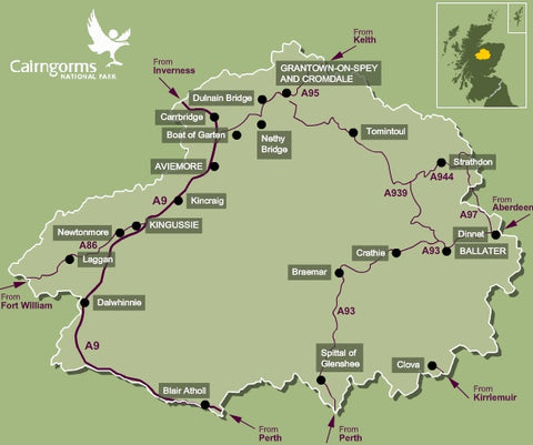
The approximate southern-boundary of the range runs from slightly east of Braemar, west along Glen Dee to White Bridge, through Glen Geldie to the head of Glen Feshie. The western-boundary runs down Glen Feshie and the River Spey to Aviemore. The northern-boundary runs roughly eastward from Aviemore through Glen More to Glen Avon. The eastern-boundary then runs up Glen Avon, and over Am Bealach Dearg to slightly east of Braemar.

Our Top 3 Routes
Meall a'Bhuachaille & Ryvoan Bothy from Glenmore Visitor Centre
This short walk with its spectacular views on good paths provides a fantastic introduction to the area for a first time visitor. It shows magnificent views over the Cairngorm National Park in a fairly easy half day. Good weather is desirable to make the most of the extensive views.
Park at the Forestry Commission Visitor Centre in Glenmore. Take a steep path to the left of the Centre through the trees to a fork in the trail. Take the left path and climb easily, following the track until the path emerges from the forest to open mountainside. After this, the trail is badly eroded and very muddy, especially if there has been wet weather. It leads upwards, heading for the Bealach between Creagan Gorm and the summit of Meal a'Bhuachaille. Turn east now and climb the west ridge to the summit.
The way on from the summit is not a clearly marked path, but head in a north easterly direction across the summit plateau for about 200metres when a clear path will appear, winding steeply down, due East to Ryvoan Bothy.
A rough track leads south west from here, becoming much smoother as it passes An Lochan Uaine and continues on to Glenmore Lodge. A footpath then runs parallel to the road, leading directly back to the Visitor Centre. Refreshments and souvenirs are available here, as well as picnic tables with scenic views across Loch Morlich.

Cairngorm & Ben Macdui from the ski centre
This walk covers two of the highest mountains in the UK, so get ready for some amazing views on your hike. Cairngorm (4,084 feet) is the sixth highest and Ben Macdui (4,295 feet) is the second. It is exceeded in height in the UK only by Ben Nevis.
Despite the height of these mountains, this particular walk is not a very strenuous one for the average fit hiker. You will first begin by walking up the Coire Cas Route which is found to the right of the ski centre car park to the top of the funicular station. From the top station, it is a straightforward walk to the top of Cairngorm. You will follow a clear, rocky path which makes Cairngorm a fairly easy climb. As you get closer to the summit, you will come across a series of cairns which appear in a line as if to guide you to the top. The very top is marked by a large cairn and when you look back, Loch Morlich can be seen below.
At this point there is no path leading onwards, but head in a south westerly direction and walk down the rocky hillside. The route passes close to Coire an t-Sneachda and Coire an Lochain, the latter of which is passed on the return route later in the walk on the opposite side of the corrie.
Following the ridge ahead, you will reach a clear path. The gradients are generally gentle here and as a result, you should progress relatively quickly. The granite tors of Beinn Mheadhoin will appear as humps on the ridge of the mountain to the left and you will pass Lochan Buidhe on the left of the path before the gradient begins to steepen. Follow another line of cairns similar to the ones on Cairngorm, they will take you in the right direction towards Ben Macdui which is about a mile further on. You will follow a rock-covered plateau to the sizeable cairn which marks the summit. Weather conditions can be cold and wet at the best of times, meaning this is an unlikely place to take a break for any length of time.
For the return route, retrace your steps back as far as Lochan Buidhe. Once you reach this point, take the path that veers to the left. Follow the path ahead in a northerly direction. The path will then pass the other side of Coire an Lochain which now appears on the right. As you follow the ridge down, eventually you return to the the start point in the car park after you cross a stream at the end.

Cairngorm Mountain via Coire an t-Sneachda from the Ski Centre
We’ve left this route to the end as it includes a grade one winter climb and should only be undertaken by those who are competent to do so. You will need two ice axes and crampons if you are intending to hike between the months of October and April. You must take great care as the area is prone to avalanche conditions during this time. You can ask for advice on climbing conditions at the ranger station in the ski centre car park.
After parking the car at the ski centre, take the path that leads to the west passing the ski tows. After about ten minutes the path forks. Take the left path and this will take you southwards towards Ston Coire an t-Sneachda. You will cross of a large boulder field. Take particular care here as the drops in between can be hazardous. Once you reach the Loch, head left and round the side of the loch where a path begins to appear underneath the Central Gully/Vent. The path will thicken and start to climb and cross diagonally towards the Goat Track.
At this point, the going is quite tough and the gradient is steepening. Once you enter the gully, continue to the left next to the rocks. The snow is at its thinnest which provides good axe and foot holds. You should expect the climb to take around an hour as it is quite demanding. Once you reach the top, turn left and follow the edge toward Cairngorm Mountain which will not yet be in view.
Keep following the edge and it will start to turn northwards and begin to drop downhill a little. Continue until you reach the 1141 metre spot height which is marked by a large cairn. Now turn east and head up the last slope towards the top of Cairngorm Mountain. The summit marker at the top provides a welcome break from the wind as you take in the views of the 4081ft giant.
When you leave, follow the line of cairns northwards away from the summit until you come to a roped path. Within 30 minutes you will reach the Ptarmigan Station. Moving on from the station, head north. The route follows the fence for around 500m before it slowly turns left where it then descends to the rear of the day lodge, where you walk through and onto the car park where you first started out.

Little Known Facts
- The Park covers 4528 square kilometres (1748 square miles). This is twice the size of the Lake District and Loch Lomond and the Trossachs National Parks. It is the biggest national park in the UK. This makes up a massive 6% of Scotland.
- Parts of the Cairngorms have been described as an arctic wilderness. The land above 600 metres which is known as the 'montane zone' is the largest area of arctic mountain landscape in the British Isles.
- Although a lot of the landscape is made up of heather-covered moors, the park is also home to forests of historical note. There are rare remnants of ancient Caledonian pine forests still standing here, and a rare pinewood that grows only in Scotland and Norway can also be found in the Cairngorms.
© 2026 Target Dry | E-commerce by WeMakeWebsites


Vaughan William
Author