- Continue Shopping
- Your Cart is Empty
February 19, 2015

Recent Articles
A Beginner’s Guide to the Cairngorms
Britain's highest mountain range, situated in the eastern Highlands of Scotland, are the Cairngorms. They are known for featuring some of the highest summits in the UK and some of the best conditions for skiing in winter.
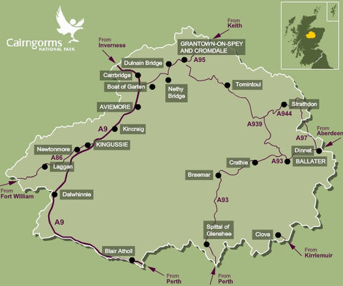
The approximate southern-boundary of the range runs from slightly east of Braemar, west along Glen Dee to White Bridge, through Glen Geldie to the head of Glen Feshie. The western-boundary runs down Glen Feshie and the River Spey to Aviemore. The northern-boundary runs roughly eastward from Aviemore through Glen More to Glen Avon. The eastern-boundary then runs up Glen Avon, and over Am Bealach Dearg to slightly east of Braemar.

Our Top 3 Routes
Meall a'Bhuachaille & Ryvoan Bothy from Glenmore Visitor Centre
This short walk with its spectacular views on good paths provides a fantastic introduction to the area for a first time visitor. It shows magnificent views over the Cairngorm National Park in a fairly easy half day. Good weather is desirable to make the most of the extensive views.
Park at the Forestry Commission Visitor Centre in Glenmore. Take a steep path to the left of the Centre through the trees to a fork in the trail. Take the left path and climb easily, following the track until the path emerges from the forest to open mountainside. After this, the trail is badly eroded and very muddy, especially if there has been wet weather. It leads upwards, heading for the Bealach between Creagan Gorm and the summit of Meal a'Bhuachaille. Turn east now and climb the west ridge to the summit.
The way on from the summit is not a clearly marked path, but head in a north easterly direction across the summit plateau for about 200metres when a clear path will appear, winding steeply down, due East to Ryvoan Bothy.
A rough track leads south west from here, becoming much smoother as it passes An Lochan Uaine and continues on to Glenmore Lodge. A footpath then runs parallel to the road, leading directly back to the Visitor Centre. Refreshments and souvenirs are available here, as well as picnic tables with scenic views across Loch Morlich.

Cairngorm & Ben Macdui from the ski centre
This walk covers two of the highest mountains in the UK, so get ready for some amazing views on your hike. Cairngorm (4,084 feet) is the sixth highest and Ben Macdui (4,295 feet) is the second. It is exceeded in height in the UK only by Ben Nevis.
Despite the height of these mountains, this particular walk is not a very strenuous one for the average fit hiker. You will first begin by walking up the Coire Cas Route which is found to the right of the ski centre car park to the top of the funicular station. From the top station, it is a straightforward walk to the top of Cairngorm. You will follow a clear, rocky path which makes Cairngorm a fairly easy climb. As you get closer to the summit, you will come across a series of cairns which appear in a line as if to guide you to the top. The very top is marked by a large cairn and when you look back, Loch Morlich can be seen below.
At this point there is no path leading onwards, but head in a south westerly direction and walk down the rocky hillside. The route passes close to Coire an t-Sneachda and Coire an Lochain, the latter of which is passed on the return route later in the walk on the opposite side of the corrie.
Following the ridge ahead, you will reach a clear path. The gradients are generally gentle here and as a result, you should progress relatively quickly. The granite tors of Beinn Mheadhoin will appear as humps on the ridge of the mountain to the left and you will pass Lochan Buidhe on the left of the path before the gradient begins to steepen. Follow another line of cairns similar to the ones on Cairngorm, they will take you in the right direction towards Ben Macdui which is about a mile further on. You will follow a rock-covered plateau to the sizeable cairn which marks the summit. Weather conditions can be cold and wet at the best of times, meaning this is an unlikely place to take a break for any length of time.
For the return route, retrace your steps back as far as Lochan Buidhe. Once you reach this point, take the path that veers to the left. Follow the path ahead in a northerly direction. The path will then pass the other side of Coire an Lochain which now appears on the right. As you follow the ridge down, eventually you return to the the start point in the car park after you cross a stream at the end.

Cairngorm Mountain via Coire an t-Sneachda from the Ski Centre
We’ve left this route to the end as it includes a grade one winter climb and should only be undertaken by those who are competent to do so. You will need two ice axes and crampons if you are intending to hike between the months of October and April. You must take great care as the area is prone to avalanche conditions during this time. You can ask for advice on climbing conditions at the ranger station in the ski centre car park.
After parking the car at the ski centre, take the path that leads to the west passing the ski tows. After about ten minutes the path forks. Take the left path and this will take you southwards towards Ston Coire an t-Sneachda. You will cross of a large boulder field. Take particular care here as the drops in between can be hazardous. Once you reach the Loch, head left and round the side of the loch where a path begins to appear underneath the Central Gully/Vent. The path will thicken and start to climb and cross diagonally towards the Goat Track.
At this point, the going is quite tough and the gradient is steepening. Once you enter the gully, continue to the left next to the rocks. The snow is at its thinnest which provides good axe and foot holds. You should expect the climb to take around an hour as it is quite demanding. Once you reach the top, turn left and follow the edge toward Cairngorm Mountain which will not yet be in view.
Keep following the edge and it will start to turn northwards and begin to drop downhill a little. Continue until you reach the 1141 metre spot height which is marked by a large cairn. Now turn east and head up the last slope towards the top of Cairngorm Mountain. The summit marker at the top provides a welcome break from the wind as you take in the views of the 4081ft giant.
When you leave, follow the line of cairns northwards away from the summit until you come to a roped path. Within 30 minutes you will reach the Ptarmigan Station. Moving on from the station, head north. The route follows the fence for around 500m before it slowly turns left where it then descends to the rear of the day lodge, where you walk through and onto the car park where you first started out.

Little Known Facts
- The Park covers 4528 square kilometres (1748 square miles). This is twice the size of the Lake District and Loch Lomond and the Trossachs National Parks. It is the biggest national park in the UK. This makes up a massive 6% of Scotland.
- Parts of the Cairngorms have been described as an arctic wilderness. The land above 600 metres which is known as the 'montane zone' is the largest area of arctic mountain landscape in the British Isles.
- Although a lot of the landscape is made up of heather-covered moors, the park is also home to forests of historical note. There are rare remnants of ancient Caledonian pine forests still standing here, and a rare pinewood that grows only in Scotland and Norway can also be found in the Cairngorms.
© 2026 Target Dry | E-commerce by WeMakeWebsites


Lucy Stevenson
Author